Chestertown

Chestertown, the county seat of Kent, the Eastern Shore of Maryland's oldest county, was founded in 1706 and served as a major port of entry during colonial times. Its brick sidewalks and attractive antique stores, restaurants and inns beckon visitors and residents alike to wander, browse and admire. A visit to Chestertown's Historic District is especially worthwhile, and includes a number of fine colonial residences, as well as some superb examples of later and more elaborate architectural styles.
Second largest district of restored 18th-Century homes in Maryland, Chestertown is also home to Washington College, the nation's tenth oldest liberal arts college, founded in 1782.
Driving Directions
Driving through Chestertown

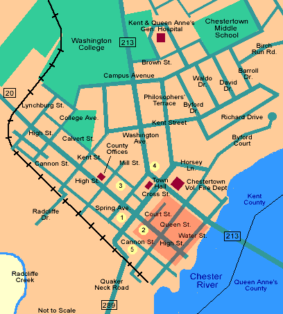
We recommend that you walk through Chestertown's Historic District, situated primarily in the area west of Highway 213 between CourtStreet and Water Street. For an excellent and detailed map of the Historic District, as well as an architectural guide to its buildings, click on this highlighted area, or click here.
There is ample parking available near the historic district, most of which is indicated by the numbered yellow circles on the adjacent map of the downtown. The circle numbered "1" is a lot accessible from Cannon Street behind the Alexander Building. Area number "2" is High Street, itself. Area number "3" is the block on Calvert Street between Spring Avenue and Mill Street, opposite the parking lot which serves the US Postal Service. Area number "4" is the parking lot in front of the Dollar General Store at the foot of and just east of Washington Avenue; and Area "5" is the large lot on Cannon Street between Cross and Queen Streets. If shopping is more to your taste, Chestertown has a wide variety of wonderful opportunities. Water Street is one-way from east to west, and so must be entered from Route 213. After entering, you will see River House on your left at 107 North Water Street.River House was built in the Federal Style in 1784 and exhibits Flemish Bond brickwork on its street facade. In 1926, the woodwork from a second-floor room was removed to the Winterthur Museum near Wilmington, DE, and is preserved there as the "Chestertown Room."
Widehall, the last house on the left on Water Street, was built by Thomas Smythe in 1770. This elaborate Georgian Townhouse is notable for its entrance, all-header bond brickwork and keystoned window lintels.The river entrance is crowned by ionic double porches. Smythe was Chestertown's wealthiest merchant, a member of the local Committee of Correspondence, and head of Maryland's Revolutionary Provisional Government from 1774 until 1776.
At the end of this block, turn left and go to the old Town Landing on the Chester River. It was here that irate local citizens boarded the brigantine, Geddes, and threw her cargo of tea and her crew overboard in protest against the tax levied on tea in 1774. This event is recreated annually during the Chestertown Tea Party Festival. This was also the dock for the steamers that traveled daily between Baltimore and Chestertown during the 19th Century.
Behind you on your left is the Customs House. The original building adjoined this structure, but is no longer standing. The current building was constructed in 1746 and was used partly for customs purposes and partly as a residence. The 1770 addition, although constructed using the same Flemish bond technique, does not have the glazed header bricks used in the older section.
Leave the Town Landing, turn left on Water Street and proceed for one block. The Hynson-Ringgold House is on your right, built in two stages on land owned by Nathaniel Hynson. Dr. William Murray purchased the lot in 1743 and built the front section of the house with its impressive hip roof and all-header bond facade. In 1767, Thomas Ringgold purchased the property and allowed his son, Thomas Ringgold, Jr. to reside there with his wife, Mary Galloway. Just prior to the death of Thomas Ringgold Sr., the large back wing which parallels Cannon Street was constructed. The interior of the east room in the front section was removed to the Baltimore Museum of Art in 1932. The house now belongs to Washington College and serves as its President's residence.
Return to High Street via Water Street and turn left. On the corner at 102 High Street is the Wickes House built ca. 1767 and set off by a gracious walled garden of Box. In the middle of the second block on the right stands the Imperial Hotel. Just beyond it is Stam Hall, built in 1866. It was used for many years as the local post office and the theater. Across High Street is the White Swan Tavern, constructed as a residence by Joseph Nicholson in 1733. It was enlarged and transformed into a tavern in the 1790's, and operated as such until the 1850's, when it became a general store. It was extensively restored and opened as a B&B in 1981.
Across High Street, you will find Memorial Park with its monuments to those from Kent County who have fallen over the years in the defense of their country. North of Memorial Park and across Cross Street is Fountain Park. The current, ornate fountain, erected in 1899, is crowned by a statue of Hebe, Goddess of Youth and Beauty and Cupbearer to the Gods. Facing Memorial Park is Emmanuel Episcopal Church. Here on November 9, 1780 a convention of Anglican clergy and laity met at the call of the incumbent Rector, the Reverend William Smith, DD. This convention declared the Church of England in the American Colonies independent of the British Crown, and adopted for the new church the name, Protestant Episcopal Church in the United States of America. The first church to occupy this site was built in 1707; the current building dates from 1767-1772. The interior of the church is well worth a visit with special attention to the fine memorial tablet in the north wall and the Tiffany window in the south wall.
The Kent County Court House is behind Emmanuel Church. The oldest section was constructed in 1860 at a cost of $11,254.00 The street adjacent to the Court House is called Court Street and is lined with small Victorian buildings, many of which contain law offices.
Return to High Street (Route 20) and follow it out of Chestertown. Stay on Route 20 for 3.5 miles, then turn left onto Route 446. At the first four-cornered intersection, turn right onto Ricaud's Branch - Langford Road. You are now driving on one of the first turnpikes constructed in the country. Directions for the remainder of the tour are available here, or through the Driving Tour links on other pages. Enjoy your visit!
Driving Tours in Kent County

