

Office of Emergency Services

Walter "Pete" Landon, Director
104 Vickers Drive, Unit D
Chestertown, Maryland 21620
Tel: 410-778-1241
Fax: 410-778-4601
General E-mail: KentOES@kentgov.org
Get MdReady for Maryland Severe Storms Awareness Week Beginning April 7
Maryland Department of Emergency Management Partners with the National Weather Service to Highlight Spring Storm Hazards, Urge Marylanders to Practice Tornado Drill
|
“Maryland Severe Storms Awareness Week is an opportunity for individuals, families, businesses, and communities to be proactive and to take action,” said MDEM’s Secretary Russ Strickland. “We encourage all residents and visitors in Maryland to participate in the Great Maryland Twister Test, review their emergency plans, and ensure they have multiple ways to receive alerts, including the MdReady WebApp and the MdReady text alert system. Taking these steps now will help protect lives, reduce disruptions, and strengthen our communities’ ability to recover when severe weather strikes.” Marylanders are encouraged to install the MdReady WebApp, which provides instant access to a wide range of emergency notifications and preparedness information to residents and visitors. To install the new WebApp, users can visit MdReady.maryland.gov and follow the prompt to easily add the MdReady shortcut to a mobile device home screen or to sign up for text alerts in English, Spanish, or in one of 185 languages. During Severe Storms Awareness Week, MDEM will focus on a specific type of hazard each day. Severe storms come in a wide variety and can bring different types of weather hazards. MDEM will be covering the difference between Watches and Warnings, common weather threats in Maryland, and precautions you can take ahead of the storm. Monday, April 7, MDEM will spotlight flooding, one of the most common weather issues in Maryland. Most flood fatalities happen when people try to drive, walk, or swim across flood waters. If you see standing water on a roadway or bridge, it is often difficult—usually impossible—to tell how deep it is or how quickly it is flowing. Remember, Turn Around, Don’t Drown. MDEM reminds everyone that April is Flood Awareness Month in Maryland. Tuesday, April 8, MDEM will discuss damaging winds. While many people focus on swirling tornadoes as a potential threat, straight-line winds and downbursts can also cause serious damage, as well. Much of the damage from the derecho storm in the summer of 2012 was caused by straight-line winds. Wednesday, April 9, MDEM will be covering tornadoes. On Wednesday, April 9 at 10 a.m., Marylanders are also invited to join MDEM and the NWS in practicing what to do in the event of an actual tornado warning during the Great Maryland Twister Test Tornado Drill. The NWS will issue a statement over National Oceanic and Atmospheric Administration (NOAA) Weather Radios about the tornado drill. Be aware, while an Emergency Alert System (EAS) test code will precede this message, the Required Monthly Test (RMT) code may not trigger some weather radios. This test code will also not trigger Wireless Emergency Alerts over cell phones. The NWS Baltimore/Washington Weather Forecast Office, which covers most Maryland jurisdictions, is coordinating this statement and drill in conjunction with their colleagues at NWS Mount Holly (PA), which covers Caroline, Kent, Queen Anne’s, and Talbot counties, and NWS Wakefield (VA), which handles Dorchester, Somerset, Wicomico, and Worcester counties. While Maryland schools, businesses, and organizations can drill at 10 a.m., they are encouraged to practice their tornado drill any time that day. Thursday, April 10, will focus on hail. Hail is a ball of ice formed in the extreme turbulence of strong thunderstorms as rain freezes and re-freezes. Sometimes this recycling of the freezing rain allows the ice to grow as large as the size of a softball. Hail is formed only in strong, dangerous storms, and the larger the hail, the more dangerous the storm. If you witness hail, get indoors as soon as possible. Friday, April 11, will center on lightning safety. More than 98 percent of lightning casualties are suffered by people outdoors. Lightning can strike more than 10 miles away from where rain is falling; most frequent fatalities occur outside of the rain band. If you can hear thunder, you are close enough to be struck by lightning. So, When Thunder Roars, Head Indoors. Visit our Severe Storms Awareness Week page for more information: https://mdem.maryland.gov/Pages/severe-storms-week.aspx. To find more preparedness information for severe storms and other hazards, please visit the following websites: mdready.maryland.gov/know-the-threats/Pages/default.aspx, weather.gov/safety, or ready.gov. Be sure to follow MDEM’s social media feeds on X (Twitter) (@MDMEMA), Facebook (facebook.com/MDMEMA), Linkedin (linkedin.com/company/maryland-department-of-emergency-management), Threads (threads.net/@mdmema>) and Bluesky (@mdmema.bsky.social). CONTACT:
|


Download the brochure here
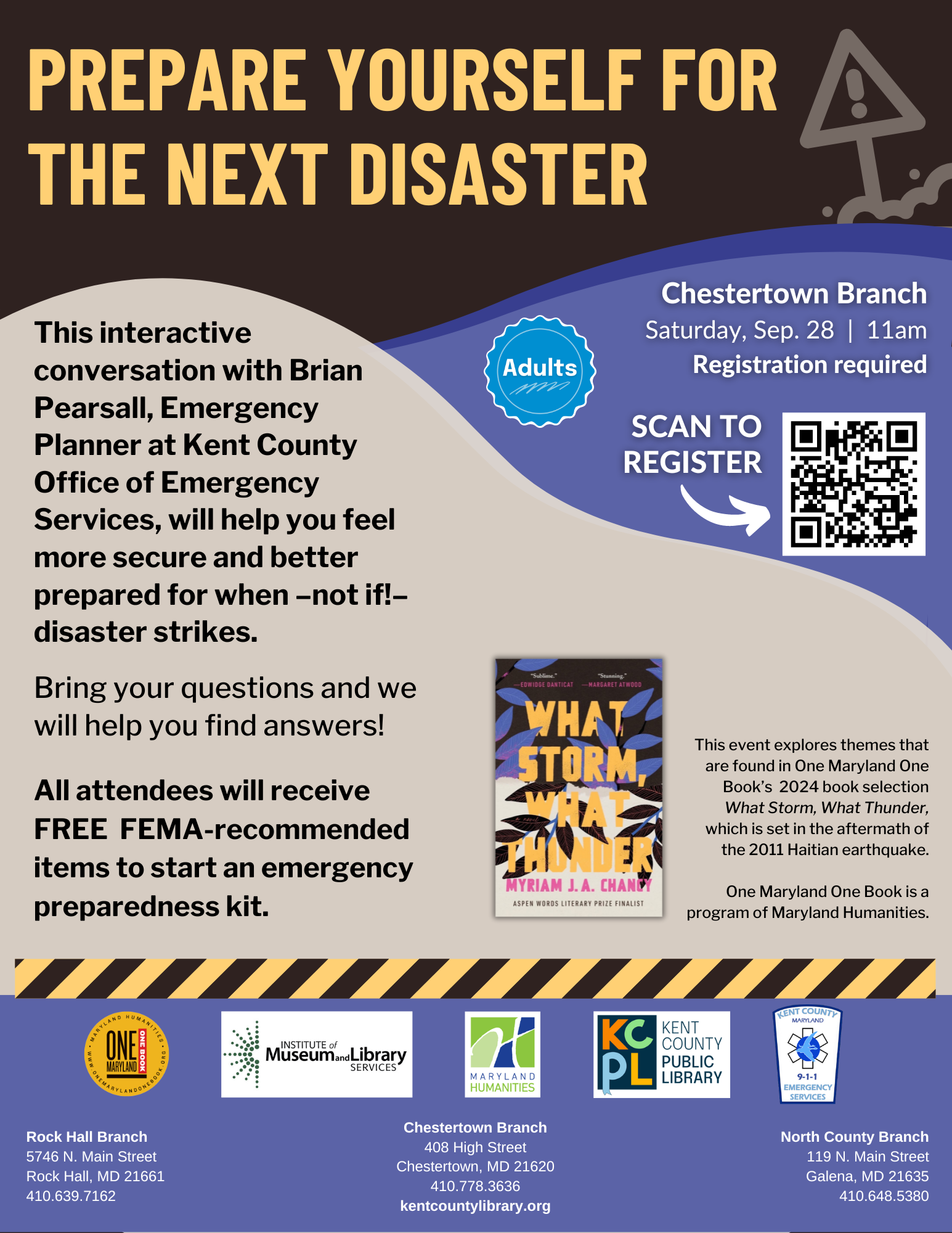
Prepare yourself for the next disaster! A One Maryland One Book Program. Click here for registration and more information
![]() The first annual 988 Day is on Sunday 9/8!
The first annual 988 Day is on Sunday 9/8!
For More Information on the 988 Suicide and Crisis Lifeline
988 offers 24/7 access to trained crisis counselors who can help people experiencing mental health-related distress. Visit the 988 website for more information about how 988 provides judgment-free support for mental health, substance use, and more.
MISSION STATEMENT
Our mission at the Kent County Office of Emergency Services is to provide rapid, professional, and compassionate emergency services to our community, ensuring the safety and well-being of all individuals in times of crisis. We are committed to excellence in emergency response, preparedness, and education, striving to minimize harm and save lives through effective coordination, innovation, and teamwork.
VISION STATEMENT
Our vision for the Kent County Office of Emergency Services is to be recognized as the gold standard in emergency response, setting the benchmark for excellence, innovation, and professionalism. We strive to continuously enhance our capabilities, partnerships, and technologies to ensure the highest level of preparedness, responsiveness, and emergency care for our community. By fostering trust, resilience, and unity, we aim to create a safer and more secure environment where every individual feels supported and protected in times of need.
The Kent County Office of Emergency Services(OES) is the coordinating agency for the emergency response for day-to-day emergencies and natural and technological hazards such as fires, floods, tornadoes, hurricanes, winter storms, chemical releases and terrorism incidents. The agency provides:
- 9-1-1 Communications
- Emergency Preparedness Safety Tips
- Guidelines for Displaying House Numbers
- Emergency Medical Services
- Everbridge Community Notification Enrollment
" The Kent County Office of Emergency Services joins the County Commissioners of Kent County in recognizing the month of September as Kent County Preparedness Month, with a proclamation and ratification of the 2023 Kent County Emergency Preparedness Plan. Thank you to the Kent County Commissioners for supporting our county and citizens recognizing the need for preparedness whether you are a resident, business or visiting. If we are all prepared before an emergency, we can all return to normal more quickly after any disaster whether natural or man-made. "Take Control 1, 2, 3"
Documents
Plans
Photos
Media Releases
Kent County will be updating the Hazard Mitigation Plan over the next several months. If you wish to be part of the team that updates the plan, or if you wish to provide comments as to its content, please contact us at kentoes@kentgov.org . For your perusal, the current Hazard Mitigation Plan is available for download - Kent County Hazard Mitigation Plan .
 The Kent County OES welcomes visitors to their facility during business and evening hours. They offer a brief orientation program and tour of the facility. To schedule a visit, please call 410-778-1241. The OES is located in the basement of the Detention Center Complex. Enter under the orange canopy at the Sheriff's Department and proceed downstairs.
Kent County OES personnel work closely with a wide variety of organizations. Listed below are links to some of these organizations:
|


